Escaped youth tracked by Eagle helicopter, found hiding in New Brighton
The young person who escaped from a youth justice facility in Rolleston has been located...

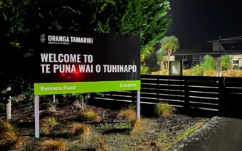
The young person who escaped from a youth justice facility in Rolleston has been located...

A person has been seriously injured on State Highway 75, Christchurch Akaroa Road. A police...

BodyFix Gym Christchurch in Phillipstown has taken out two major honours at the Exercise New...

Local MPs have found areas of agreement on major Resource Management Act reforms, during a...

A series of public events have been organised across Christchurch and Lyttelton over the coming...

A woman was taken to hospital after a ‘water incident’ at Parakiore Recreation and Sport...
Blue Skies Weather is forecasting snow for the Canterbury High Country and plains.
It says airflow will tend southwesterly over Canterbury tonight and remain for a few days, with fronts mostly passing out to the east of the South Island. The coldest air will be over Canterbury on Wednesday, and southwesterly airflow will ease on Thursday.
For farmers:
Expect 3-5cm accumulating above 600m tomorrow, clearing mid to late afternoon. A further 1-3cm may accumulate inland and on the western hill country above 400m on Wednesday, but 1-3cm is likely in brief light snow flurries above 400m on Banks Peninsula and about the coastal hills of North Canterbury. These showers will clear by early Thursday.
For travellers:
Snow tomorrow should be just high enough to avoid disruption to mountain passes, and snow flurries on Wednesday should mostly miss inland areas, so only a small risk of disruption then.
Elsewhere
Some light snow flurries to low levels may affect roads in Southland and Otago early on Wednesday but heavy falls are not expected.