Escaped youth tracked by Eagle helicopter, found hiding in New Brighton
The young person who escaped from a youth justice facility in Rolleston has been located...
Proudly powered by VAST – NZ’s leading digital advertising billboard company. FIND OUT MORE


The young person who escaped from a youth justice facility in Rolleston has been located...

A person has been seriously injured on State Highway 75, Christchurch Akaroa Road. A police...

BodyFix Gym Christchurch in Phillipstown has taken out two major honours at the Exercise New...

Local MPs have found areas of agreement on major Resource Management Act reforms, during a...

A series of public events have been organised across Christchurch and Lyttelton over the coming...

A woman was taken to hospital after a ‘water incident’ at Parakiore Recreation and Sport...
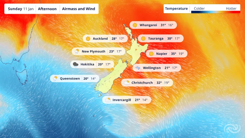
Temperatures across the country are forecast to be much warmer than your average summer’s day this weekend, as the remnants of the Australian heatwave cross the Tasman Sea.
Eastern areas will see the highest daytime temperatures, particularly around Hawke’s Bay where thermometers could see upwards of 35°C on both Saturday and Sunday.
An area of high pressure is driving westerly winds over the Tasman, picking up moisture along the way and delivering that hot, moist air direct to our doorsteps.
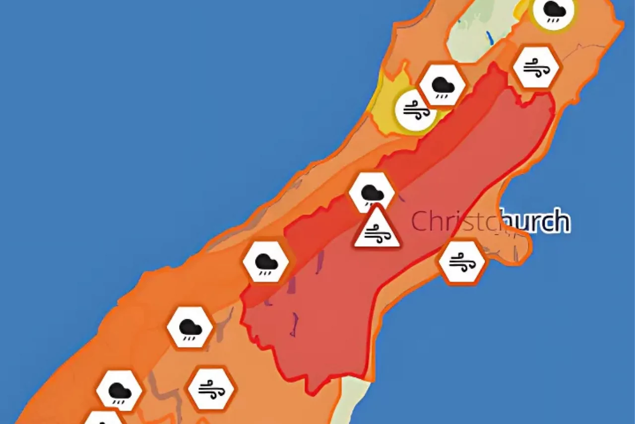
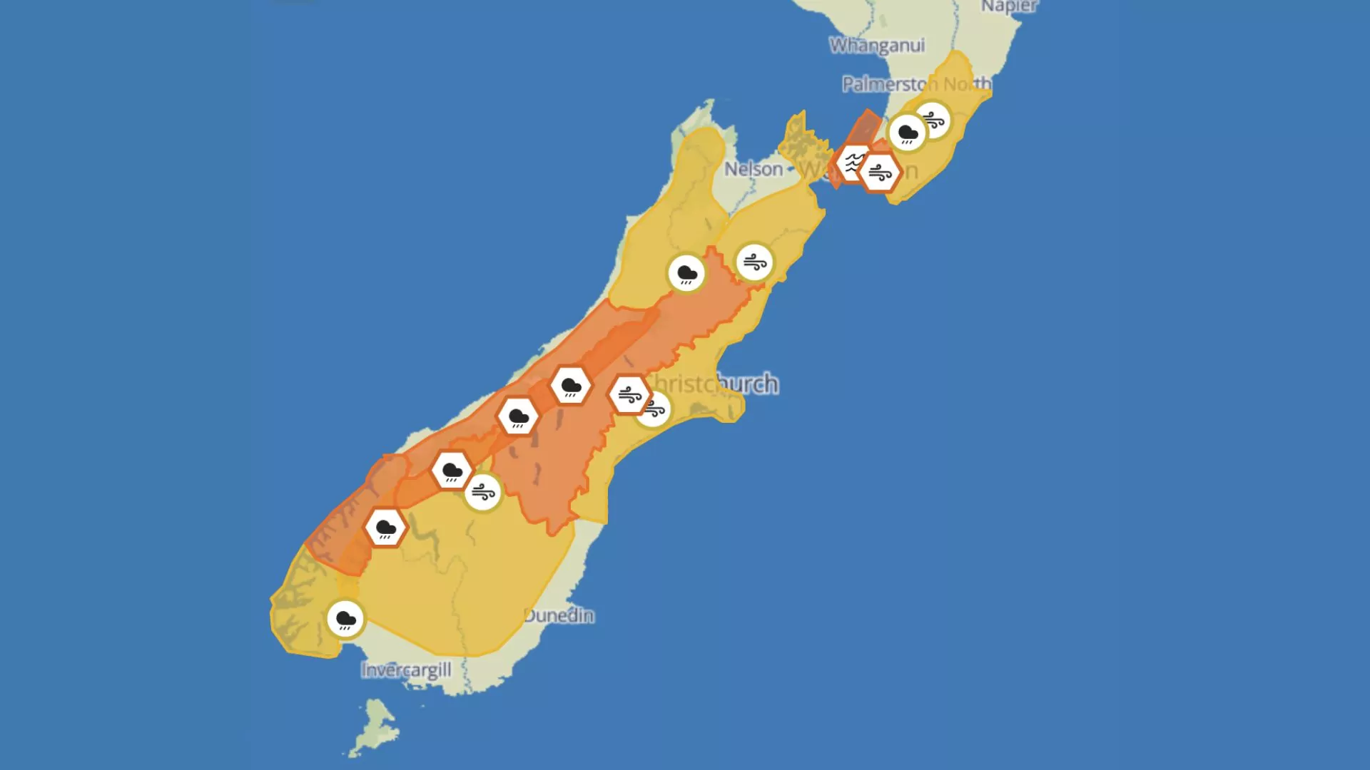
A Heavy Rain Watch is currently in place from this afternoon (Thursday) until Friday morning for Fiordland and is expected to be the first of more Severe Weather Watches and Warnings to come for this weekend for not only Heavy Rain but Strong Winds too.
Heat Alerts have also been issued ahead of the weekend: Whakatāne, Napier, Hastings, Motueka, Blenheim, and Kaikōura have all met their thresholds for the alerts for Friday. However, the heat ramps up on Saturday and Sunday, with forecasts indicating 35 to 37°C around Hawke’s Bay; 30 to 31°C in Northland; 28 to 31°C for North Canterbury and Marlborough.
MetService meteorologist Clare O’Connor said, “Some January temperature records are expected to tumble over the weekend, which highlights the extremes we could reach.
“Thankfully we aren’t receiving the full brunt of the Australian heat – which saw some cities reach 40 to 45°C – but these are still high temperatures for New Zealand and planning accordingly is crucial.”
For the South Island, heat is not the only extreme in the forecast.
The West Coast and Fiordland are expected to see warning amounts of rainfall through Saturday and Sunday, and strong winds cross the Southern Alps, affecting Otago and Canterbury, adding to the heat in the east. The strong winds also reach the lower North Island.
O’Connor said “The hottest temperatures coincide with the strongest winds in the east due to the Foehn Effect, and extra care should be taken in places with increased risk of wildfires around any activity that could produce sparks.
A return to more standard weather is forecast for the coming week, so it’s better to wait a couple of days than to take the risk.”
The Foehn Effect describes how warm, moist air dries out and warms up as it crosses a mountain barrier, a common occurrence over the Southern Alps and the eastern ranges of the North Island.