Graphic: Metservice
Cold southerlies may bring heavy snow to parts of the South Island late Wednesday and early Thursday
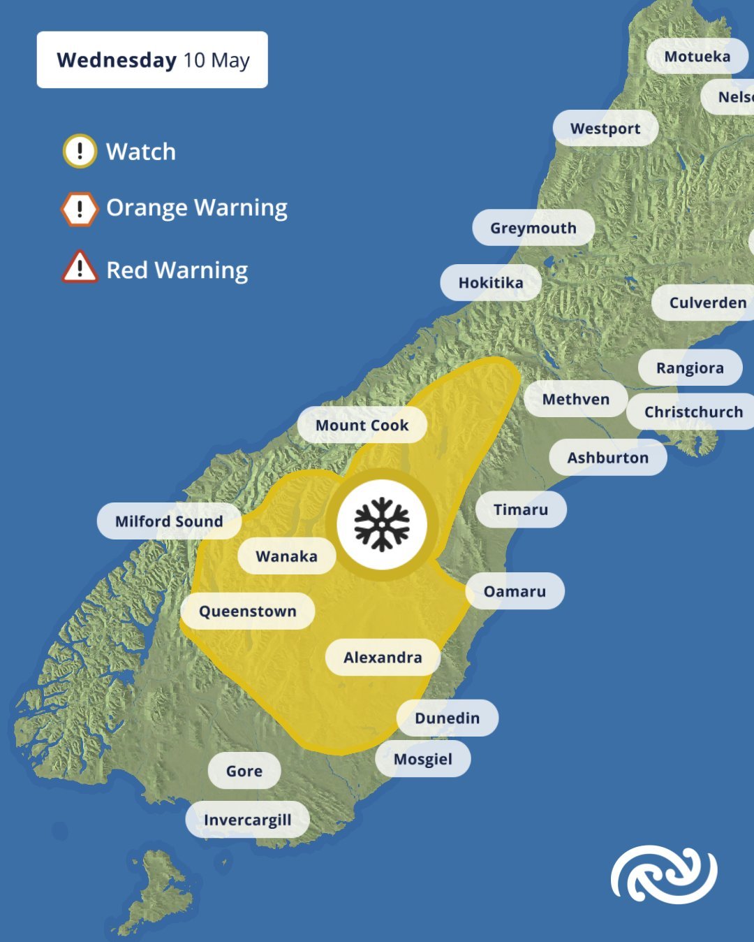
A strong, cold southerly change is spreading over the South Island today and is expected to bring snow to the hills and mountains, with possible heavy falls about parts of Southland, Otago and Canterbury.
Heavy Snow Watch
Area: The Mackenzie Country
Period: 10hrs from 8pm Wed, 10 May – 6am Thu, 11 May
Forecast: Snow is likely above about 600 metres, with heavy falls above 800 metres, where accumulations may approach warning criteria of greater than 10 cm in 6 hours.
Area: Northern hills of Southland north to the Waitaki River, excluding the lower-lying parts of North Otago, Dunedin and Clutha
Period: 10hrs from 4pm Wed, 10 May – 2am Thu, 11 May
Forecast: Snow is likely above 400 or 500 metres, with heavy falls above 700 metres, where accumulations may approach warning criteria of greater than 10 cm in 6 hours.
Issued: 9:05am Wed, 10 May
Next update: 10pm Wed, 10 May
Road Snowfall Warnings
Road Snowfall Warning
Area: Desert Road (SH1)
Period: 10hrs from 1am – 11am Thu, 11 May
Forecast: Snow showers are expected to develop above 900 metres around midnight tonight and continue during Thursday morning. During Thursday morning, around 1 cm of snow may accumulate on the road near the summit.
Area: Lewis Pass (SH7)
Period: 11hrs from 4pm Wed, 10 May – 3am Thu, 11 May
Forecast: Snow showers are possible above 700 metres late this afternoon and evening. 2 to 5 cm of snow may accumulate on the road above 800 metres from late Wednesday afternoon until early Thursday morning.
Area: Arthur’s Pass (SH73)
Period: 6hrs from 4pm – 10pm Wed, 10 May
Forecast: Snow showers are possible above 700 metres late this afternoon and evening. 1 to 2 cm of snow may accumulate on the road near the summit late Wednesday afternoon and in the evening.
Area: Porters Pass (SH73)
Period: 6hrs from 1am – 7am Thu, 11 May
Forecast: Snow showers are expected above 600 metres from early Thursday morning. During Thursday morning, 1 to 3 cm of snow may accumulate on the road above 800 metres.
Area: Lindis Pass (SH8)
Period: 4hrs from 10pm Wed, 10 May – 2am Thu, 11 May
Forecast: Snow showers are expected to develop above 600 metres this evening. Up to 2 cm of snow may accumulate above 800 metres Wednesday evening into early Thursday morning.
Area: Crown Range Road
Period: 10hrs from 4pm Wed, 10 May – 2am Thu, 11 May
Forecast: Snow is expected to develop above 500 metres late this afternoon, and 3 to 6 cm of snow may accumulate above 800 metres from late Wednesday afternoon until early Thursday morning.
Area: Milford Road (SH94)
Period: 19hrs from 10am Wed, 10 May – 5am Thu, 11 May
Forecast: Snow showers above about 500 metres are expected today and early tomorrow. During Wednesday morning and early afternoon, 3 to 5 cm of snow may accumulate on the road above 700 metres and then this evening and early Thursday morning, a further 2 to 3 cm of snow may accumulate.